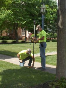
What is an ALTA survey?
If you are looking to purchase a commercial or developmental piece of property, chances are your lender may have asked you to provide an ALTA survey before the loan is approved. So what is it and what do you need to know?
An ALTA survey is a very specific type of survey that follows national standards developed by the American Land Title Association in conjunction with the National Society of Professional Surveyors. In addition to locating the boundary of your property, an ALTA survey identifies physical features, evidence of possession, and other conditions that could indicate adverse title claims.
Basically, the survey helps the title company be sure that there is nothing on your land that is going to indicate someone else has a claim to it and that you are going to be able to use the land in the way you intend.
For example, an ALTA survey will look at everything within five feet of the boundary lines, as well as trails, fences, easements, or overhangs that encroach onto the property. Simultaneously, a title examiner will supply a title commitment, including documents that might affect the title, such as liens, easements, mortgages, rights of way, reservation of mineral rights, and others. Those items are then plotted on the survey to see exactly how they impact the property.
Standards for an ALTA survey are typically revised every five years, with the next revision expected in 2016. Unlike a mortgage location survey, which varies from state to state and is typically used for residential property, an ALTA survey is normally specific to commercial or industrial properties.
Before requesting an ALTA survey, be sure to confirm with your lender if there are any specific requirements that they will need. For instance, to verify zoning compliance, the number of stalls in existing parking lots may be needed. This is just one of several “Optional Table A” items. Knowing those requirements upfront can expedite the delivery of the survey and potentially save you money in the long run.
An accurate ALTA survey will ensure there are no surprises that may negatively affect the use of the property.
Advocating for Landscape Architecture
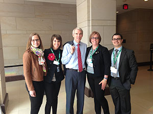
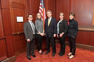 Last week, Lynne Nischwitz, the Landscape Architecture Studio Leader at the Kleingers Group, traveled to Washington DC as part of her role as Vice President of the Ohio American Society of Landscape Architects (ASLA) to advocate for landscape architecture and causes important to the profession.
Each year ASLA sends landscape architects from across the country to Washington DC to raise the visibility of the profession with legislators and help promote the solutions that landscape architects can help provide to various national problems.
This year, the group was advocating for three things:
- Ensuring that bicycle and pedestrian paths and walkways continue to receive support in the latest Transportation Alternatives Program and are not subject to the same regulations as large highway projects.
- Protecting the Land and Water Conservation Fund which provides grants supporting the local park, conservation, trail, and recreation projects.
- Promoting the National Park Service Centennial challenge, ensuring money is available for the maintenance of the nation’s national parks.
The group also spoke about the importance of licensure in the landscape architecture profession. The education, experience, and examination required to earn a license ensures that licensed landscape architects can “keep the public safe from hazards, protect and maximize the use of natural systems and resources, and prevent damage to public or private property from changes in the built environment”, according to ASLA.
Lynne and fellow ASLA members met with Senator Rob Portman and Senator Sherrod Brown and Lynne also met with a representative from Steve Chabot’s office.
To learn more about the 2015 Advocacy Day or about the issues visit www.ASLA.org.
4 Ways the Kleingers Group Will Make Your Next Traffic Count Better
The Kleingers Group recently acquired unmanned bird’s eye perspective video capture devices, a new way to conduct traffic counts. Rather than requiring a person to stand at an intersection, the new technology converts images to data using video collected through a battery-operated camera.
The benefits to you are:
- Access to Multiple Days of Data at No Extra Cost: A traditional intersection traffic count only collects one day of data. Sometimes something unexpected happens, such as a crash on a nearby street that diverts traffic and creates a high count. With video capture devices, The Kleingers Group has access to several days of data to ensure the traffic count is giving a representative picture.
- Counts at Abnormal Locations (such as Roundabouts) at A Reduced Cost: Busy roundabouts are notoriously hard to count because the person counting has to follow the car along its entire path through the roundabout. Often roundabouts require multiple people to conduct a count, raising costs. With video capture, costs don’t increase.
- More Information than Just Numbers: Sometimes traffic patterns need to be observed to get the full picture. An intersection may be too busy for a person to count the traffic and simultaneously make notes of needed observations. Now, video can be reviewed directly, allowing the engineer to make the necessary observations, often at a sped-up rate. The end result is more information to help you make smart decisions.
- The Ability to Review Data at A Later Time: Sometimes specific questions about existing conditions don’t arise until after the traffic count is finished. With video capture, The Kleingers Group can go back and review the video on file to answer new questions, saving a repeat field visit.
Read how The Kleingers Group is using new technology to create an innovative parking solution on Blue Ash Road or contact The Kleingers Group to discuss how we can use video capture and smart analysis to help solve your traffic or parking problem.
What’s the Back-Up Plan? Changing the Parking Scheme on Blue Ash Road
Backing out of 90-degree on-street parking into a busy road is generally recognized as a very dangerous parking maneuver. Drivers often can’t get a good view of oncoming traffic before pulling into it, leading to driver anxiety and accidents.
So when The Kleingers Group started a safety improvement study for Blue Ash Road in the City of Deer Park, the existing 90-degree on-street parking was a major concern.
The transportation and infrastructure group used Miovision Scout Data Collectors—a camera that records video for use in data collection and observation—to observe parking maneuvers along the corridor. With video capture, they were able to cost-effectively perform over a day’s worth of observations at a birds-eye view.
What they found was surprising: a good portion of drivers were already backing into the existing 90-degree parking spaces to enable themselves to be able to see when they pulled out later.
This knowledge led The Kleingers Group to consider reverse angle parking, an innovative solution.
Unlike traditional angled parking, in which drivers pull into a space head-on, reverse angle parking encourages drivers to drive just past an open space and back in, vastly improving visibility when they pull out. The result is parking that is safer for both drivers, cyclists, and pedestrians.
Although reverse-angle parking is less common than traditional angled parking, the data from video observation showed that a culture of backing into on-street parking already existed.
“We learned that a good portion of drivers were already making maneuvers similar to the changes we were proposing,” Traffic Engineer Dave Meyer said. “Reverse angle parking will allow much greater visibility when you are exiting a parking spot.”
Although education campaigns will still be necessary to acquaint residents with the alternative parking scheme, many drivers won’t have to substantially change their habits. By encouraging the remaining drivers to also back into their parking space, accidents should be reduced and parking will be safer for motorists, cyclists, and pedestrians.
The result is increased economic development—including visitors, shoppers, and diners—as people feel safer parking and, as a result, frequenting the area.
Improvements to Blue Ash Road are expected to be completed in 2019.