Doing the Right Thing for Our Communities – Christopher Morris, PLS
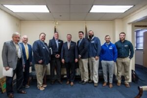
The Kleingers Group’s own Shelby County Kentucky Surveyor and regionally infamous “sharp-dressed-man,” Christopher Morris, PLS, recently met with Kentucky Speaker of the House David Osborne in his Frankfort office. As part of the “Home Builders Association of Kentucky Day at the Capitol,” Morris found it especially important to support the HBAK Workforce Development policy enabling students to use KEES funds for various educational and training programs in the skilled trades.
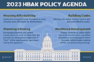
KEES Funds are slated for Kentucky Workforce Development. The HBAK policy would allow their application by Kentucky residents toward both registered skilled trade apprenticeship programs and degree-based coursework. These could include land surveying certificate programs, bachelor’s level degrees in civil engineering, and registered apprenticeship programs as an electrician, ironworker, carpenter and more.
Morris says, “No civil engineering or construction project can reach its full potential without the applied knowledge, skill, talent, and wisdom of both college graduates and experienced, skilled tradesmen. With this policy, more Kentucky graduates can get KEES funds to pursue the path they’re passionate about – whether it’s in the skilled trades or in college – it’s up to them. That’s great for every project – in every Kentucky community.”
The Kleingers Group and its talented teams recognize the need for a strong and skilled workforce throughout our AEC sector. It is critical to support both university and skilled trade educational programs. For more information on Kentucky’s KEES Fundin

Program, click here.
Winton Woods City School district receives Outstanding Project Award from Learning by Design
Built on the foundations of trust, respect, and responsibility, the Winton Woods South Campus Elementary provides 1st through 6th-grade students with spaces to explore deeper learning experiences.
Having committed to Project-Based learning in 2011, the district recognized that their kids were the experts on what their new school should be. These student visionaries identified four themes that drove the design of their new school: Community & Culture, Show & Tell, Eat & Learn, and Inside & Outside.
Read more about Winton Woods’ award-winning Elementary School at Learning By Design.
Project Team
Architect: SHP
Land Surveying: The Kleingers Group
UofL Health unveils $144 million project to upgrade, expand downtown hospital
Surrounded by elected officials, UofL Health leaders unveiled the rendering to a new $144 million project Thursday morning inside the Jackson Street outpatient center.
The project is a massive expansion at the downtown hospital.
Speaking to the crowd present, UofL Health CEO Tom Miller said, though the price tag for the project is $144 million, its impact will be priceless.
“Every day, for the last year, we have not been able to meet the need of our patients,” Miller said. “We never say no to anybody in need, but we’ve held 40 patients a day in our emergency room in our emergency unit. [Those are] Patients that are never getting a bed. We had to fix that.”
Photo Credit: University of Louisville
Read more about the University of Louisville’s hospital expansion at WLKY.
Linking Real-World Engineering Problems to K-12 Educators & UC CEEMS
Studies have shown for decades that the integration of STEAM programs within K-12 education is important to the development of students. These programs are designed to set up children earlier with a strong understanding of STEAM skills, while cultivating students as a future interest for national economic prosperity.
Over the past several years Steve Korte, Group Leader for Kleingers’ Southwest Ohio Institutional Group, has volunteered in many ways for the University of Cincinnati CEEMS program. The Cincinnati Engineering Enhanced Mathematics and Science Program (CEEMS) is led by the University of Cincinnati in partnership with 14 Cincinnati-area school districts. One of the main goals of UC’s CEEMS program is “real world applications: connections to engineering,” and the classroom presentations provide great linkage for the students in understanding how the subjects they are learning apply to the “real world.”
During the program, teachers design a challenged-based learning activity to engage their students in decision making, strategic planning and evaluate plan revisions. At the end of each session, participating teachers are given the opportunity to present their final “units,” displays and videos for judging. Steve served as a volunteer judge during the Closing Day Showcase earlier this month, providing constructive feedback and guidance to the educators.
“As a graduate of the UC College of Engineering, I take tremendous pride in being able to connect back via CEEMS,” says Steve. “It is a great way for me to give back to my community all while educating the stewards for the next generation of engineers” he continues.
The Oak Hills School District, Steve’s alma mater, is a partner in the CEEMS program. “Many of my formal education worlds come together through the CEEMS program. I have been able to take back my professional experience and college education at UC to teach students about how math and science really come together. I even had the opportunity to present at Delhi Middle School, my old stomping grounds,” Steve shared.
Through many years of volunteering, Steve has grown many relationships with teachers and administrators in the Cincinnati area, which has led to several classroom presentations to middle school and high school math/science students. Steve has also sat on numerous panels in an open forum with math and science teachers to discuss what engineering companies are looking for in college graduates (technical skill sets, software programs and soft skills).
“As a group of engineers, surveyors and landscape architects who use math, arts and sciences every day, it is important to myself and others at Kleingers to educate teachers. Giving teachers the tools to explain real-life applications and how STEAM subjects impact their students’ future careers is huge,” says Steve.
To learn more about the University of Cincinnati’s CEEMS program, visit their website: http://ceas.uc.edu/special_programs/ceems/CEEMS_Home.html
Learn more about the “Closing Day Showcase” here: http://ceas.uc.edu/news-1314/ceems-closing-day-showcase-facilitates-promising-classroom-resul.html
10 Things to Consider When Planning a Sports Park
It’s not every day that an Owner takes on planning a 100+ acre sports park, but when the scenario arises, The Kleingers Group brings proven experience to the team. Over the years, Kleingers has designed a number of large-scale sports parks and has found that many of the same considerations tend to come up during our design process. We would like to share with you what to consider before you take on your sports park design.
1. Connect to Existing Community Assets
Creating transportation linkages to other community resources such as parks, schools, YMCAs, and more will encourage participation at the new development. Pursue ways to blend the new park with its surroundings and work with neighbors and stakeholders to build support for the project. Leverage connections through existing infrastructure like trailways, complete streets, and other multi-modal systems will provide easy access for bicyclists and pedestrians who visit the facility.
2. Create a Site that is Safe, Easy to Use, and Navigate
Speaking of connecting the site with pedestrians, it’s also important to design ways to keep them safe, especially from vehicular traffic. Maintain separate vehicle travel zones and pedestrian travel zones when possible and provide for safe and clearly marked crosswalks to help minimize conflicts. Branding, wayfinding, and creative use of landscape theming will help visitors with vehicles travel to their destination within the site more efficiently while minimizing user frustration.
Oftentimes, large sports complexes lack adequate wayfinding due to oversight or budget concerns. Proper wayfinding design can help users get to where they need to be while also creating a recognizable brand for the sports park and the associated owner.
3. All Sports Park Owners are in the Parking Business
Did you know that many competitive organizations that bring tournaments to sports parks require minimum parking per event? Organizers hosting tournaments require anywhere between 50-100 spaces per field, some require even more. Believe it or not, sports park owners are in the parking business. Visitors have high expectations that parking should be easy and accessing their field shouldn’t be a hassle. Tournament organizers must meet the demands of their clients, which means balancing the site’s infrastructure is important to everyone’s bottom line. Planning for enough parking close to destination points within the design allows for better traffic flow and provides better ADA access throughout the site. The site layout needs to balance ease of access without being interrupted by large parking areas, or losing the vibrancy of an active and energized park.

4. Plan for Flexibility: Master Planning the Site for Optimum Use
Creating a park with the most flexible layouts will mean more options for end-users. Engineering the field grading is a key component. Fields should be carefully engineered to accommodate high-end games and large events with the ability to host smaller games within the same space without compromising the playable area, including crowns and field orientation.
Master planning a complex for multiple sports provides flexibility when attracting special events. Understanding how to plan for and design sports parks for flexibility amongst sports, whether soccer, football, lacrosse, rugby, Australian football, ultimate frisbee, baseball, softball, or cricket will attract a larger audience. Knowledge of national sports trends will allow the field designer to guide a client through the planning stages while meeting their needs and measured desires within the area.
5. Coordinate with Local Municipalities
Working with local interests and shareholders during the design process helps to ensure that everyone has a voice in the process of designing the sports park. Creating opportunities for partnerships early will help generate buy-in from key stakeholders and community members. Our experience in working through this relationship helps guide programming, affordability, and ultimately desired priorities.
6. Plan for Extra Traffic in the Area
More often than not, any new development brings additional traffic to a site. Traffic engineers can provide traffic studies to better understand current traffic conditions and anticipated changes and recommendations.

7. Sports Engineering is Key: Grading, Drainage & Field Performance Will Keep Them Coming Back
Creating space for tournaments is big business and retaining that business helps any sports park be successful. If the grading, slopes, drainage, playing surfaces, and other amenities are not designed properly, tournament organizations will take their business down the road to the competing sports park. Competitive organizations have a business to run and their business model depends on feedback from players and parents who use the fields, facilities, and park amenities at these events. Positive survey feedback will increase the chances that they return again for another event.
8. Plan for Attendees Who are not Players or Spectators
A large portion of the sports park business is creating a fun and comfortable experience for attendees. Creating spaces, such as playgrounds, within eyesight of a group of playing fields keeps that family with one child playing in the game and another bored on the sideline entertained and comfortable. Providing a trail system allows for visitors to take a break between tournament games, connect to another game across the complex, or meander to a ‘hub’ with concessions and restrooms nearby. Trails also appeal to pedestrians and bicyclists across the community.
9. Create a Space for Vendors
An often-overlooked element of the sports complex business is providing adequate space for vendors who are often on hand during a sporting event selling sports equipment, promotional items, and more to parents and other attendees. Creating ‘vendor zone’ spaces convenient to tournament sites is a key selling point to those looking to bring competition to the area.
10. Plan for Championships and Celebrations
Another trend in design that we see is the inclusion of championship fields. These higher-quality fields, sometimes utilizing synthetic turf, are designed with more seating and are typically located in prominent areas of the complex to draw more crowds as competitions wind down. Additionally, we see the integration of amphitheater spaces where teams celebrate their accomplishments with awards ceremonies.
Summary
These design considerations are a fraction of the items to explore when creating a sports park. At Kleingers/Sportworks, we understand the business of sports parks, the competition that takes place inside and outside the park, and the investment owners take in creating these opportunities for revenue. We also understand good engineering, traffic, sports field engineering, survey and landscape design, and the importance of getting all of these things done right for the bottom line and ultimate success of any sports park complex.
Considerations When Planning Next Large-Scale Complete Streets Project
Case Study: Wilmington Pike and Feedwire Road Roadway and Intersection Improvements
Construction was recently completed on the multi-phase project which took a major intersection within Montgomery County from 3-lanes to 9-lanes at the largest point. Already a highly traveled area in the county, a new adjacent development was driving the need for improvements at a large scale. The project area is populated with many retail establishments, restaurants, and homes. All of these stakeholders would be impacted by the development that included Costco, Kroger Marketplace, Cabella’s, and additional outparcels with smaller retail and restaurant space.
The Kleingers Group worked closely with the City of Centerville, homeowners, business owners, and other stakeholders to ensure the design would meet increased traffic capacity needs, accommodate pedestrians, and help keep area businesses operational.
Below are examples of things to consider when planning your next large-scale complete-streets, roadway design project.
Minimizing the Impacts on Businesses Through Design
Maintenance of traffic (MOT) in any roadway project can make or break the businesses affected during construction. Kleingers found challenges throughout the three phases of the project but worked to address or even predict each one.
Number one, the entire project scope (all 3 phases) was designed early in the process to ensure that each end of the project would have the least impact on the right-of-way, and ultimately the existing businesses along with the design. Creating this initial master plan allowed our engineers to create a design that provided no disruption to the area businesses. For some businesses, losing parking spaces could mean closing their doors. Because of Kleingers’ universal look early in the design process, no parking stalls were affected during construction or lost after completion of the project. Kleingers’ worked with the city to help predict future phases and affected areas to ultimately help save money.
Speaking of saving money, and resources, Kleingers’ carefully coordinated plans to help save on temporary paving costs by salvaging pavement from other phases of the project. The salvaged pavement was used to reduce construction costs where temporary pavement was needed for maintaining 2-lanes of traffic.
Not only was the area already highly populated, but the thoroughfare was an important route for nearby hospitals and other emergency crews. Kleingers coordinated with local hospitals, the city, and its emergency services departments to ensure 2-lanes would remain operational during the life of construction so that emergency crews could operate, business as usual.
More than Just Roadway Improvements – Complete Streets
Complete streets are defined as ‘streets for everyone’ and ‘a means to make it easy to cross the street, walk to shops, and bicycle to work.’ The Wilmington Pike and Feedwire Road project was designed to address safety for all travelers beyond motorists, including pedestrians, bicyclists, and transit riders.
With traditional sidewalks provided on one side, 8-foot wide meandering paved trails, and a concrete bus stop for Dayton RTA riders, the project was challenged with not only creating the means for safety but also creative drainage solutions.
Our traffic engineers took into account ADA and pedestrian safety when designing for three traffic signals along with the project. The design provided key elements such as voice-activated pedestrian push buttons that are timed and integrated with the signal system; ADA curb ramps; and landscape mounds along with the development which obstructs headlights that beam into on-coming traffic. The project also incorporates a pull-off bus stop for Dayton RTA riders along with ADA access and a gazebo that protects transit riders. All of these elements working together provide safe access for pedestrians and bicyclists in the area.
The city looked to Kleingers to help find the balance of economics when comparing adding more right-of-way (ROW) costs or providing environmental and water quality structures to address drainage design. Typically, on most projects where adding more ROW to a project has little impact on local businesses or homeowners, the simple solution is to create larger ditches to handle drainage runoff. In this particular project where the project was constrained by several existing businesses, the cost-effective solution to drainage was to add water quality structures. In doing so, the designers were able to also address environmental concerns while maintaining precious ROW.
The Loon – Designing Safe ‘Out-Of-The-Box’ Solutions for U-Turns
Roadway engineers are continually looking for ways to improve vehicular and pedestrian safety. A rare, ‘out-of-the-box solution for drivers who want to safely cross or make a U-turn on a divided roadway is through the use of a ‘Loon through-turn’ design. So, what is a loon? The loon is pavement that is constructed outside of the normal traffic lane within the right-of-way space. This additional area allows vehicles, especially larger ones, to safely make a U-turn on a roadway divided by a median.
Where lanes were widened to accommodate the increase in traffic, a median was created to provide safer access for those who live along this stretch of road. The installation of the loon helps those who have headed northbound access their homes on the other side of the new median without the safety implications of crossing large amounts of oncoming traffic.
Predicting Construction Conflicts in A 3-Phase Project
Often, unforeseen construction issues are a leading contributor to increased construction costs during a project. Kleingers considered all aspects of construction coordination between project phases when designing the roadway improvements, such as drainage, utility coordination, elevation changes with a neighboring development project, and much more.
The Kleingers’ team was able to provide contractors with finished elevations for coordination of major utilities, including water mains, gas mains, and power distribution lines. By telling contractors exactly where to locate lines, even in areas that had not been graded for elevations, those utility contractors could be on-site once during the life of the project without additionally impacting the schedule later in construction. It also meant that site contractors would have to grade the site less and fewer materials would be required, ultimately saving time and money.
By working alongside the designers for the adjacent site development project, The Kleingers Group could provide regular updates on a continuous basis. Adjusting for site elevation, drainage, and utility changes during the project’s design phase. This allowed Kleingers to maintain continuous control of the project while in the field. This extra coordination helped Kleingers quickly accommodate for construction surprises in the field, helping to alleviate downtime on the project.
In summary, a successful large-scale complete street project will require close coordination among all stakeholders during the design phases to mitigate common budget and schedule busting events.
Experience the Life of A Surveyor
Experience the life of a surveyor through the lens of a smartphone camera. #surveylife
Learn more about The Kleingers Group, our wonderful teams of surveyors, and all the great work we have the privilege of doing here.
New ALTA/NSPS Land Title Survey Standards
It’s the final day of National Surveyors Week. This week we’ve celebrated by posting about some little known facts about surveying at Kleingers, talking about 3D laser scanning and bathymetric surveys. Today, we end useful information for lenders, title professionals and surveyors: the new ALTA/NSPS Land Title Survey Standards.
As many of you may know, the new “Minimum Standard Detail Requirements for ALTA/NSPS Land Title Surveys” went into effect on February 23, 2016…replacing the previous 2011 version. The original standards went into effect in 1962 and were unchanged until 1979. Since then, several revisions have been adopted and the 2011 standards offered the most extensive changes, being the first rewrite since their creation in 1962. We now seem to be on a five year cycle of review and revisions with the 2016 version consisting mostly of minor clarifications to some of the more confusing statements in the 2011 standards.
However, the new standards do provide a few significant changes for lenders, title professionals, and surveyors to be aware of. The first and most obvious change is the title. Instead of “ALTA/ACSM” the standards are now referred to as “ALTA/NSPS” as the National Society of Professional Surveyors is the legal successor organization to the American Congress on Surveying and Mapping. Some of the other more significant changes are as follows:
Section 5.E.iv. This section requires the surveyor to identify above ground evidence of utilities. It is important to note that this used to be item 11(a) of the Optional Table A, but is now a mandatory requirement for all new surveys.
Section 6.B. This section discourages the preparation of a new description, but if needed, requires the surveyor to place a note explaining why a new description was prepared, and how the new description relates to the land described in the record description.
Table A. Item 18. This item clarifies that wetlands can only be shown if they have been located by a qualified specialist hired by the client.
Table A, Item 18 of the former standards was an optional item requiring the surveyor to note the existence of “evidence of the site being used as a solid waste dump, sump or sanitary landfill”. In its place, a new requirement was added to Table A, Item 8 requiring the surveyor to show “substantial areas of refuse”.
Notwithstanding these new standards, the surveyor must understand and account for all of the various requirements he or she may be operating under, and assure that the most stringent of those (including the normal standard of care) has been met.
Bathymetric Survey – National Surveyors Week
It’s the third day of the National Surveyors Week celebration here at The Kleingers Group. Already this week we’ve covered little known facts about surveying at Kleingers, and 3D laser scanning. Today we’ll cover bathymetric surveying.
When someone mentions the phrase “bathymetric survey” you probably envision scenic views of ocean shoreline, perhaps a busy seaport, an oil platform in the Gulf of Mexico, or at least a sailboat somewhere in the Great Lakes region. Rarely would you think of central or southwest Ohio…or would you?
The term “bathymetry” originally referred to the ocean’s depth relative to sea level, although it has come to mean “submarine topography,” or simply the depths and shapes of underwater terrain.
In the same way that topographic maps represent the three-dimensional features (or relief) of overland terrain, bathymetric maps illustrate the land that lies underwater. Surveyors with The Kleingers Group have had several opportunities to try their hand at bathymetric surveying over the years…although admittedly at a somewhat smaller scale than may come to mind in a coastal region.
Our central Ohio group recently supported George J. Igel Company in their efforts to provide protection for the Smothers Road Causeway on the Hoover Reservoir and to help address erosion control issues that have occurred over the years due to fluctuating reservoir levels. By combining GPS and sonar equipment, one of our survey crews utilized a small boat to obtain existing underwater topography and monitor construction progress in waters up to forty-five deep.
Another recent project developed underwater contours of a 2.3-mile portion of the Great Miami River in Hamilton, Ohio. Originally performed a few years earlier to aid the development of a competitive course for the Miami University rowing team, the survey was recently updated to determine the effects of siltation from a recent construction project.
So, the next time you pass a body of water somewhere in Ohio and wonder what kind of strange fishing equipment is being used…maybe it isn’t fishing equipment at all!
Kleingers Trains Miami Students to Build Water Systems in S. America

For more than 13 years, Engineers Without Borders has been building engineering projects that empower communities to meet their basic needs.
With 300 chapters across the United States, more than 15,900 volunteers work together to provide engineering services and have impacted more than 2.5 million lives.
Mike Brunner, Water Resources Group Leader at The Kleingers Group, is currently acting as a mentor for the group, helping to train Miami University students who plan to travel to Ecuador, South America or Rwanda, Africa. Under the guidance of a mentor, the students will provide engineering services to build water systems that ensure the communities have access to water.
In late September, Brunner helped the students learn a variety of hands-on skills and the practice of engineering and surveying theory, including how to run an elevation level circuit, mix and place concrete, construct water piping systems, and test concrete beams.
Particularly popular was the process of breaking beams, which was done by having increasing numbers of students stand on the beams, which were positioned 3 inches off the ground until they broke. This was preceded by reviewing the design calculations and making predictions of how many students it would take to break them and how much they would deflect before breaking.
At an upcoming meeting this weekend, Brunner will help teach the student volunteers about building masonry walls.
Each training session prepares students for civil engineering, surveying, and other experience they may need on their upcoming trip.
“I had been looking for an organization like this, with an opportunity to give back and work with students for a long time,” Brunner said. “This really is a wonderful organization.”
Engineers Without Borders is organized by local chapters that partner directly with communities, mostly international, on projects to meet the community’s self-identified needs. The vast network of dedicated volunteers ranges from first-year engineering students and engineering professionals to public health professionals.
The over-arching philosophy of EWB-USA is to partner with communities in a sustainable way, and through the use of appropriate technology, so that they have ownership in the project(s) and will be able to maintain the project facilities long-term.
Along with two or three other local professional engineers, Brunner meets weekly with the student volunteers to provide advice and direction on the engineering/technical aspects of the project, as well as to guide them through the development of the project documents and EWB-USA paperwork.
Two different teams of Miami students from the chapter, along with a mentor, traveled to Ecuador and Rwanda last year to gather survey data that is being used to design the projects and to meet the local community leaders and citizens. Trips for the construction phase are being planned for this year.
Kleingers Pleased to Sponsor Ohio Challenge Hot Air Balloon Festival

Each year, The Kleingers Group conducts the measurements for the Ohio Challenge Hot Air Balloon Festival, measuring the distance between dropped beanbags and the targets.
The Kleingers Group is pleased to once again sponsor The Ohio Challenge Hot Air Balloon and Skydiving Festival!
For more than a decade, The Kleingers Group has conducted the measurements for the event, measuring the distance between beanbags dropped from the balloons and the targets during the competitions.
This year, we will be out there again with the robotic total station to help make the measurements needed to declare a winner.
Each year up to 40 of the country’s best balloon pilots compete in the three-day challenge while tens of thousands of people enjoy the two-day festival.
In addition to the competition, visitors can enjoy a balloon glow, skydiving performances, balloon rides, a car show, games, entertainment, and food.
The 13th annual Ohio Challenge Hot Air Balloon Festival will be held July 10 – 12 at Smith Park in Middletown.
Visit www.ohiochallenge.com for more information.
What is an ALTA survey?
If you are looking to purchase a commercial or developmental piece of property, chances are your lender may have asked you to provide an ALTA survey before the loan is approved. So what is it and what do you need to know?
An ALTA survey is a very specific type of survey that follows national standards developed by the American Land Title Association in conjunction with the National Society of Professional Surveyors. In addition to locating the boundary of your property, an ALTA survey identifies physical features, evidence of possession, and other conditions that could indicate adverse title claims.
Basically, the survey helps the title company be sure that there is nothing on your land that is going to indicate someone else has a claim to it and that you are going to be able to use the land in the way you intend.
For example, an ALTA survey will look at everything within five feet of the boundary lines, as well as trails, fences, easements, or overhangs that encroach onto the property. Simultaneously, a title examiner will supply a title commitment, including documents that might affect the title, such as liens, easements, mortgages, rights of way, reservation of mineral rights, and others. Those items are then plotted on the survey to see exactly how they impact the property.

Standards for an ALTA survey are typically revised every five years, with the next revision expected in 2016. Unlike a mortgage location survey, which varies from state to state and is typically used for residential property, an ALTA survey is normally specific to commercial or industrial properties.
Before requesting an ALTA survey, be sure to confirm with your lender if there are any specific requirements that they will need. For instance, to verify zoning compliance, the number of stalls in existing parking lots may be needed. This is just one of several “Optional Table A” items. Knowing those requirements upfront can expedite the delivery of the survey and potentially save you money in the long run.
An accurate ALTA survey will ensure there are no surprises that may negatively affect the use of the property.