New ALTA/NSPS Land Title Survey Standards
 It’s the final day of National Surveyors Week. This week we’ve celebrated by posting about some little known facts about surveying at Kleingers, talking about 3D laser scanning and bathymetric surveys. Today, we end useful information for lenders, title professionals and surveyors: the new ALTA/NSPS Land Title Survey Standards.
As many of you may know, the new “Minimum Standard Detail Requirements for ALTA/NSPS Land Title Surveys” went into effect on February 23, 2016…replacing the previous 2011 version. The original standards went into effect in 1962 and were unchanged until 1979. Since then, several revisions have been adopted and the 2011 standards offered the most extensive changes, being the first rewrite since their creation in 1962. We now seem to be on a five year cycle of review and revisions with the 2016 version consisting mostly of minor clarifications to some of the more confusing statements in the 2011 standards.
However, the new standards do provide a few significant changes for lenders, title professionals, and surveyors to be aware of. The first and most obvious change is the title. Instead of “ALTA/ACSM” the standards are now referred to as “ALTA/NSPS” as the National Society of Professional Surveyors is the legal successor organization to the American Congress on Surveying and Mapping. Some of the other more significant changes are as follows:
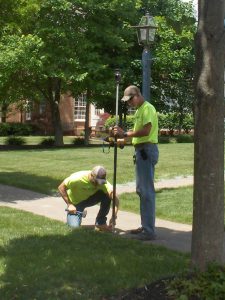
Section 5.E.iv. This section requires the surveyor to identify above ground evidence of utilities. It is important to note that this used to be item 11(a) of the Optional Table A, but is now a mandatory requirement for all new surveys.
Section 6.B. This section discourages the preparation of a new description, but if needed, requires the surveyor to place a note explaining why a new description was prepared, and how the new description relates to the land described in the record description.
Table A. Item 18. This item clarifies that wetlands can only be shown if they have been located by a qualified specialist hired by the client.
Table A, Item 18 of the former standards was an optional item requiring the surveyor to note the existence of “evidence of the site being used as a solid waste dump, sump or sanitary landfill”. In its place, a new requirement was added to Table A, Item 8 requiring the surveyor to show “substantial areas of refuse”.
Notwithstanding these new standards, the surveyor must understand and account for all of the various requirements he or she may be operating under, and assure that the most stringent of those (including the normal standard of care) has been met.
Bathymetric Survey – National Surveyors Week
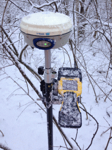
It’s the third day of the National Surveyors Week celebration here at The Kleingers Group. Already this week we’ve covered little known facts about surveying at Kleingers, and 3D laser scanning. Today we’ll cover bathymetric surveying.
 When someone mentions the phrase “bathymetric survey” you probably envision scenic views of ocean shoreline, perhaps a busy seaport, an oil platform in the Gulf of Mexico, or at least a sailboat somewhere in the Great Lakes region. Rarely would you think of central or southwest Ohio…or would you?
The term “bathymetry” originally referred to the ocean’s depth relative to sea level, although it has come to mean “submarine topography,” or simply the depths and shapes of underwater terrain.
In the same way that topographic maps represent the three-dimensional features (or relief) of overland terrain, bathymetric maps illustrate the land that lies underwater. Surveyors with The Kleingers Group have had several opportunities to try their hand at bathymetric surveying over the years…although admittedly at a somewhat smaller scale than may come to mind in a coastal region.
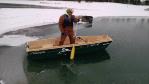
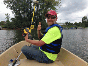 Our central Ohio group recently supported George J. Igel Company in their efforts to provide protection for the Smothers Road Causeway on the Hoover Reservoir and to help address erosion control issues that have occurred over the years due to fluctuating reservoir levels. By combining GPS and sonar equipment, one of our survey crews utilized a small boat to obtain existing underwater topography and monitor construction progress in waters up to forty-five deep.
Another recent project developed underwater contours of a 2.3-mile portion of the Great Miami River in Hamilton, Ohio. Originally performed a few years earlier to aid the development of a competitive course for the Miami University rowing team, the survey was recently updated to determine the effects of siltation from a recent construction project.
So, the next time you pass a body of water somewhere in Ohio and wonder what kind of strange fishing equipment is being used…maybe it isn’t fishing equipment at all!
Welcome to National Surveyors Week 2016!
Welcome to National Surveyors Week 2016!

Although we like to believe The Kleingers Group name is synonymous with surveying in central and southwestern Ohio, there are several services that many people are still surprised to find out we offer.
As part of our celebration this week, we will be doing short profiles on 3D laser scanning, hydrographic/bathymetric surveys and at the end of the week, we’ll provide an update on the latest changes to ALTA survey specifications. You can learn more about ALTA surveys here.
You can also participate in our Facebook poll to select your favorite surveying picture. Each week, we put three pictures up for a vote, but this week we’ll feature 10. At the end of the year, we will select a winner.
But first, some little known facts about surveying at The Kleingers Group:
Kleingers Is One of The Largest Surveying Operations in Ohio
With 25 surveyors on staff, including ten licensed surveyors, Kleingers is able to deploy up to ten crews at a time.
We are particularly proud of these numbers because it means we are able to serve clients quickly. Whether it is a small project that requires just one crew or a large project, requiring several crews, Kleingers is able to work on several projects at one time, meaning clients never have to wait long for their information.
Additionally, with offices in Cincinnati, Dayton, and Columbus, The Kleingers Group is able to shift personnel to ensure projects are handled quickly and accurately. We are familiar with jurisdictional requirements and property research throughout the state.
Combined, the Kleingers Group Staff Have More than 430 Years of Surveying Experience
We aren’t exactly johnny-come-lately to this business. Our guys have the experience to be prepared for even the unexpected. We’ve been doing this a long time and we hope it shows.

While we are proud to use the latest technology, the best equipment doesn’t mean much without the wherewithal to understand what information is important, when technology might be wrong, and when there may have been an omission. We believe additional experience means fewer mistakes and better quality documents for our clients.
The Staff in The Surveying Department Have Been with The Kleingers Group for An Average of 10 Years
Why does this matter? It means we have a cohesive group of surveyors that are used to working together. They are used to working as a team and understand Kleingers’ processes, meaning we can work more quickly and get work done for our clients with less hassle. Quality expectations are known and communication with the client is well-coordinated. In the end, we think it makes us easier to do business with.
What is an ALTA survey?
If you are looking to purchase a commercial or developmental piece of property, chances are your lender may have asked you to provide an ALTA survey before the loan is approved. So what is it and what do you need to know?
An ALTA survey is a very specific type of survey that follows national standards developed by the American Land Title Association in conjunction with the National Society of Professional Surveyors. In addition to locating the boundary of your property, an ALTA survey identifies physical features, evidence of possession, and other conditions that could indicate adverse title claims.
Basically, the survey helps the title company be sure that there is nothing on your land that is going to indicate someone else has a claim to it and that you are going to be able to use the land in the way you intend.
For example, an ALTA survey will look at everything within five feet of the boundary lines, as well as trails, fences, easements, or overhangs that encroach onto the property. Simultaneously, a title examiner will supply a title commitment, including documents that might affect the title, such as liens, easements, mortgages, rights of way, reservation of mineral rights, and others. Those items are then plotted on the survey to see exactly how they impact the property.
Standards for an ALTA survey are typically revised every five years, with the next revision expected in 2016. Unlike a mortgage location survey, which varies from state to state and is typically used for residential property, an ALTA survey is normally specific to commercial or industrial properties.
Before requesting an ALTA survey, be sure to confirm with your lender if there are any specific requirements that they will need. For instance, to verify zoning compliance, the number of stalls in existing parking lots may be needed. This is just one of several “Optional Table A” items. Knowing those requirements upfront can expedite the delivery of the survey and potentially save you money in the long run.
An accurate ALTA survey will ensure there are no surprises that may negatively affect the use of the property.